
The Elements of Innovation Discovered
The Elements of Innovation Discovered
Metal Tech News - October 28, 2022
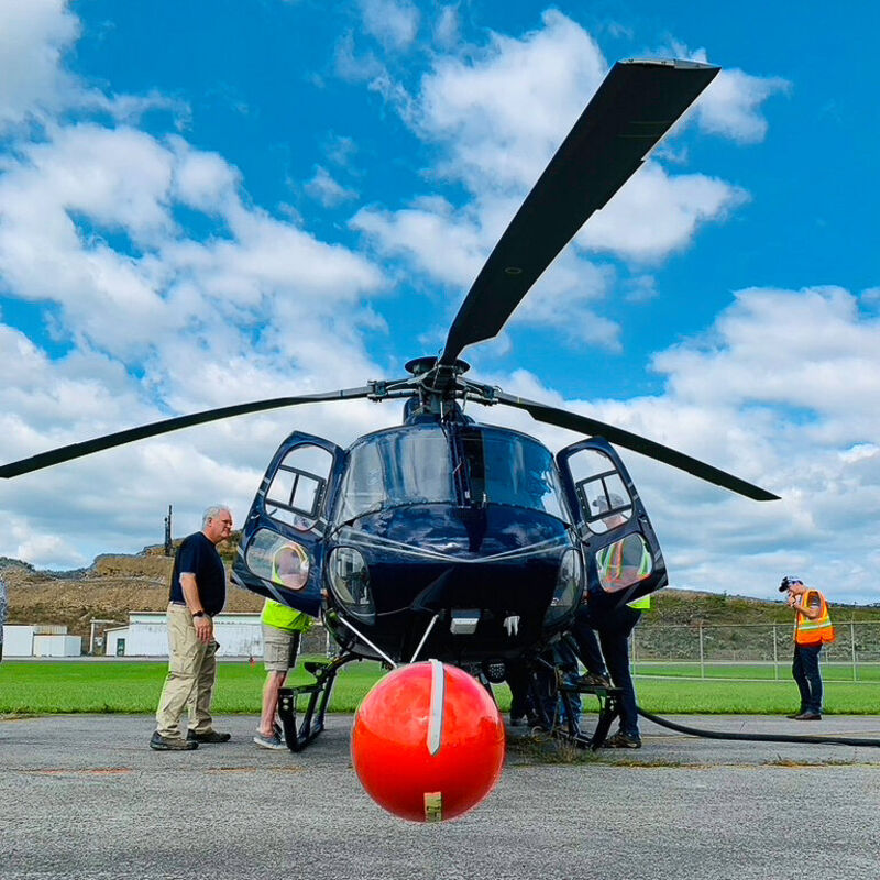
Helicopter with equipment for conducting geophysical surveys, such as the Earth MRI magnetic and radiometric surveys to be flown over portions of the American Great Plains and mountainous areas along the Colorado-Wyoming border.
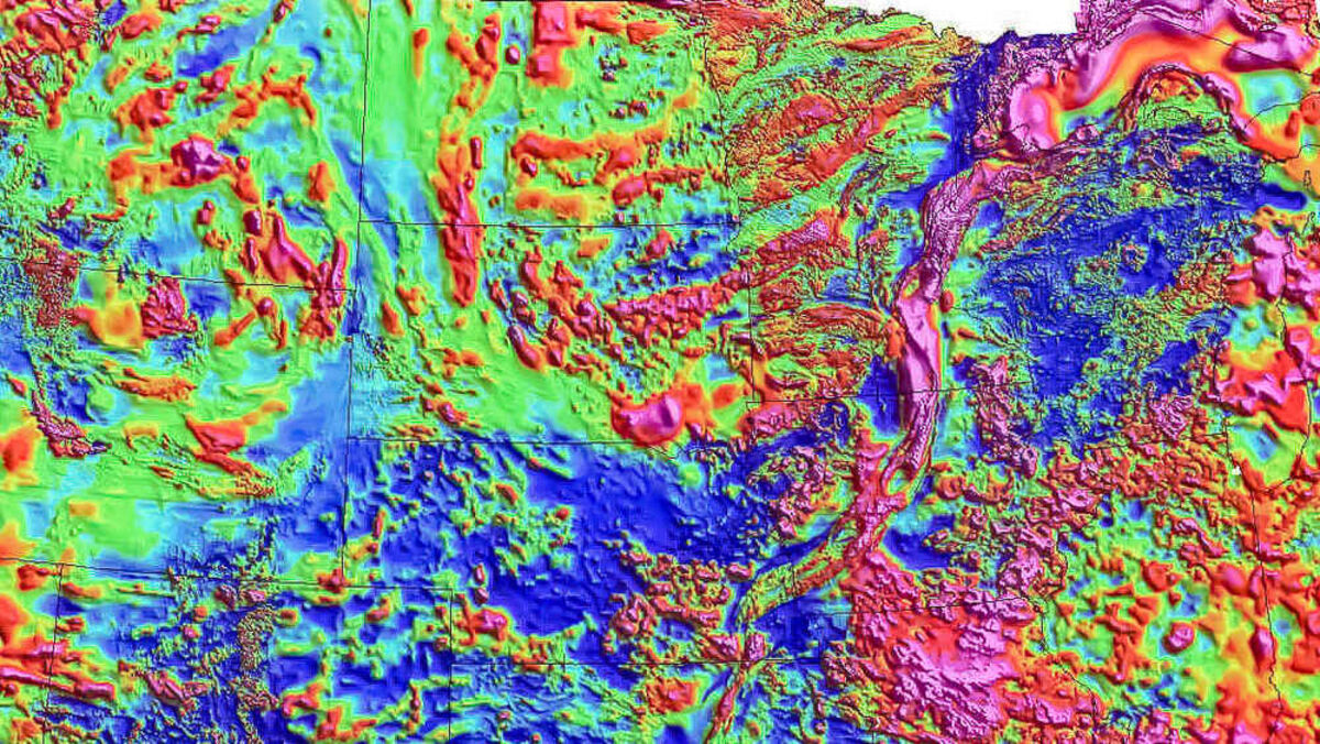
Map of composite magnetic data from geophysical surveys over the northern portion of the American Great Plains. Earth MRI will offer more detailed information on priority areas.
In its ongoing quest to identify domestic sources of the 50 minerals deemed critical to America's economy and security, the U.S. Geological Survey is investing $6 million to scan northern Great Plains states and mountains spanning the Colorado-Wyoming border for 40 of these minerals essential to powering everything from household appliances and electronics to clean energy and advanced technologies.
This program is being carried out under the Earth Mapping Resources Initiative, or Earth MRI, a cleverly named program under which the USGS is partnering with state geologists to better understand America's geology and critical mineral resource potential through new mapping, geophysics, and geochemical sampling.
"Merging federal resources with local knowledge of the state surveys creates an efficient and thorough venue to quickly further national understanding of the distribution of our resources," said Association of American State Geologists President Erin Campbell.
So far this year, Earth MRI programs have been launched to search for critical minerals in the Appalachian Mountains, Ozark Mountains, American Southwest, and Alaska.
Now, the USGS has announced two new programs that will involve airborne magnetic and radiometric geophysical surveys to aid in the search for critical mineral resources along the Colorado-Wyoming border and four northern Great Plains states. Much like the Earth MRI name implies, these surveys provide geologists with a picture of the rock formations that lie beneath the Earth's surface.
"I'm looking forward to this project because the magnetic data collected on this airborne survey improve our understanding of the region's geologic history and its potential for critical minerals," said USGS scientist Ben Drenth, the USGS lead researcher on this survey. "In addition, the radiometric data collected simultaneously will directly aid geologic mapping of surface soil types, which, in turn, will help increase our understanding of shallow water resources."
Roughly $3.2 million of the Earth MRI funds will be invested in the search for critical minerals in parts of Iowa, Minnesota, Nebraska, and South Dakota.
Geophysical surveys, such as those being carried out under the Earth MRI program, are particularly beneficial across these Great Plains states. While mountainous areas provide geologists with plenty of outcropping rocks to map and sample to understand the geology and mineral content of the area, the bedrock geology of the Great Plains is largely buried under thick layers of soil.
"This partnership portends a truly exceptional opportunity for understanding the deeply buried – and effectively hidden – geology of northeastern Nebraska," said R.M. Joeckel, a Nebraska state geologist. "This project is the kind of well-planned regional effort that can put geophysical data into a more meaningful regional context than ever before. I suspect that we will learn far more than what we imagined."
The magnetic surveys carried out over portions of Nebraska and the other Great Plains states will identify the amount of magnetic minerals, primarily magnetite, in deeply buried rocks. This allows geoscientists to "see through" nonmagnetic rocks and cover such as vegetation, soil, and water to identify magnetic anomalies that reveal geological features such as faults, folds, and dikes deep within the Earth.
The radiometric data provides clues to the relative amounts of potassium, uranium, and thorium in exposed rocks and soil. This information offers clues to the type of mineralization that lies below.
The data from these combined surveys offer geoscientists an MRI-like view of otherwise unseen geology and information on where buried mineral deposits might be located.
"Not only will these airborne geophysical surveys provide further data to help Iowa Geological Survey geologists better understand the complex Precambrian geology in northwest Iowa, but they will also provide valuable information for mapping the surficial geology in the region," said Keith Schilling, Iowa state geologist and director of the Iowa Geological Survey. "We look forward to the results and hope that this work leads to future economic investments in northwest Iowa."
The survey will investigate the Great Plains states' potential for eight individual critical minerals and two element groups that represent 19 others. These critical mineral commodities are:
• Chromium – Primarily used in stainless steel and other alloys.
• Cobalt – An ingredient in lithium-ion batteries and superalloys.
• Lithium – Primarily for rechargeable batteries for electric vehicles and electronics.
• Nickel – Used for special alloys, stainless steel, and lithium-ion batteries.
• Niobium – An ingredient in strong steels and superalloys for aerospace.
• Platinum group elements – Five critical minerals used in catalysts.
• Rare earth elements – 14 critical minerals used in magnets and catalysts.
• Scandium – Used in lightweight and durable alloys and fuel cells.
• Tin – An alloy metal that is used in solders in virtually every electronic device.
• Titanium – Overwhelmingly used as a white pigment or metal alloy.
Another roughly $2.8 million of the Earth MRI funds will be invested in the search for critical minerals in the Sierra Madre-Elkhorn Mountains and Medicine Bow Mountains that span the Colorado-Wyoming border.
"Thanks to years of close collaboration between the USGS, Colorado Geological Survey and Wyoming State Geological Survey, the resulting geophysical survey will provide geoscientists an unparalleled dataset in a region with promising critical and precious mineral potential," said Erin Campbell, a Wyoming state geologist and director of the Wyoming State Geological Survey.
Much like the Great Plains program, magnetic and radiometric surveys will be flown over these mountainous areas. The data from these surveys will assist geoscientists in mapping rocks that may contain mineral deposits, faults that may rupture during an earthquake, areas that may be prone to increased radon, and areas likely to contain groundwater or energy resources.
"Having this state-of-the-art geophysical data available before our geologists begin to map the region will provide us an incredible glimpse into the subsurface geology and help us better understand the mineral systems at depth," said Matt Morgan, a Colorado state geologist and director of the Colorado Geological Survey.
The survey will investigate the potential for 20 individual critical minerals and two element groups that represent 19 others in the mountains spanning the Colorado-Wyoming border. These critical mineral commodities are:
• Antimony – Used in batteries, flame retardants, and low-friction metals.
• Arsenic – Use in lumber preservatives, pesticides, and semiconductors.
• Beryllium – An alloying agent utilized by the aerospace and defense industries.
• Bismuth – Low melting point metal used in medical and atomic research.
• Chromium – Primarily an ingredient in stainless steel and other alloys.
• Cobalt – An ingredient in lithium-ion batteries and superalloys.
• Fluorspar – Used to manufacture aluminum, gasoline, and uranium fuel.
• Gallium – Semiconductor used for integrated circuits and optical devices like LEDs.
• Germanium – Semiconductor used for fiber optics and night vision applications.
• Indium – Used in a conducting film applied to flat-panel displays and touchscreens.
• Lithium – Primarily for rechargeable batteries for electric vehicles and electronics.
• Magnesium – Used in furnace linings for manufacturing steel and ceramics.
• Manganese – An ingredient for steelmaking and lithium-ion batteries.
• Nickel – Used for special alloys, stainless steel, and lithium-ion batteries.
• Niobium – An ingredient in strong steels and superalloys for aerospace.
• Platinum group elements – Five critical minerals used in catalysts.
• Rare earth elements – 14 critical minerals used in magnets and catalysts.
• Scandium – Used in lightweight and durable alloys and fuel cells.
• Tantalum – Chemically inert metal used in electronic components, mostly capacitors.
• Tellurium – An ingredient used in steelmaking and thin-film solar panels.
• Tin – An alloy metal that is used in solders in virtually every electronic device.
• Titanium – Overwhelmingly used as a white pigment or for metal alloys.
• Vanadium – Used in steel and titanium alloys, as well as rechargeable batteries.
• Zirconium – An ingredient in high-temperature ceramics and superconducting magnets.
The initial airborne geophysical survey will be followed by additional investments, including new geologic maps, topographic surveys, geochemical sampling, and other techniques to study the chemistry of mine wastes and surrounding lands.
"Through these investments, the U.S. Geological Survey is making critical scientific advancements in data mapping and preservation that will equip future generations," said U.S. Department of Interior Assistant Secretary for Water and Science Tanya Trujillo.

With more than 16 years of covering mining, Shane is renowned for his insights and and in-depth analysis of mining, mineral exploration and technology metals.


Reader Comments(0)