
The Elements of Innovation Discovered
The Elements of Innovation Discovered
Allots $5.8M for critical minerals exploration in two regions Metal Tech News - May 17, 2023
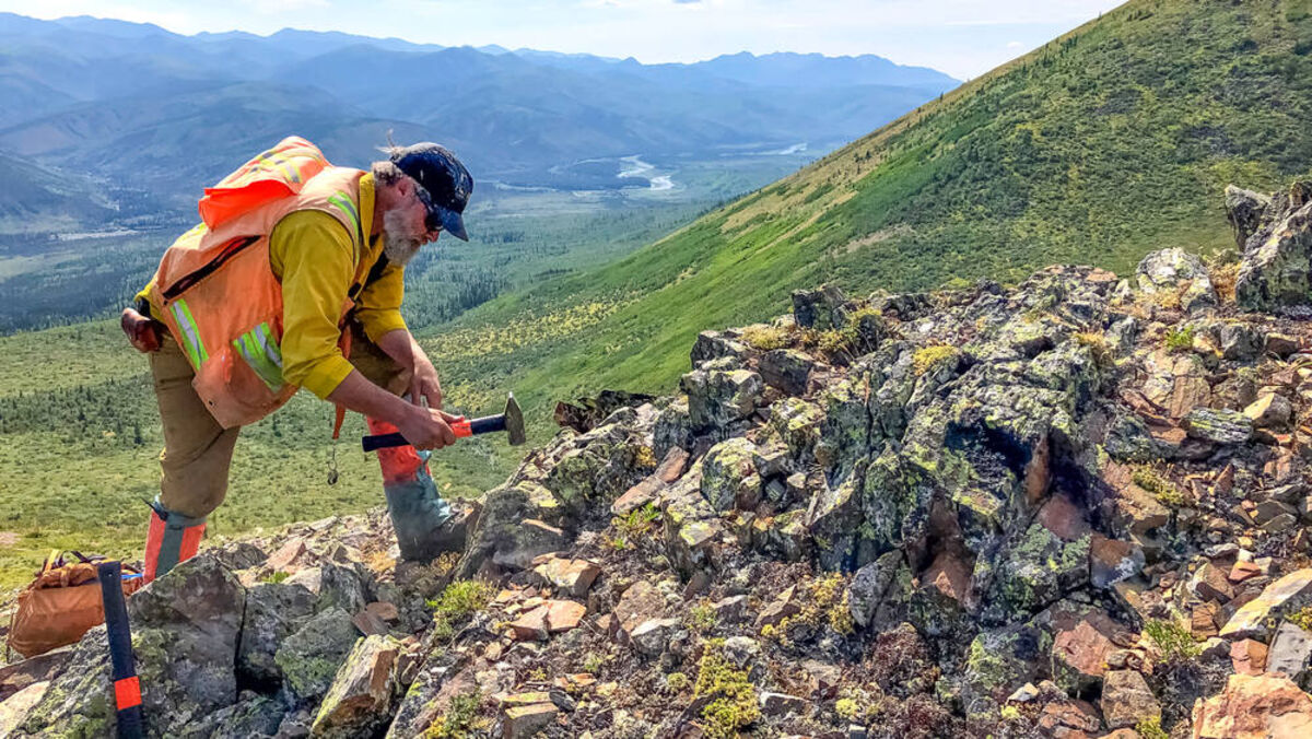
One aspect of the USGS Earth MRI program is the mapping and sampling of surfacing geology in areas known for their critical mineral potential. This photo shows USGS geoscientist Jamey Jones sampling an outcrop in Interior Alaska.
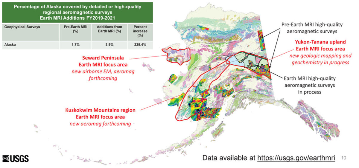
Map showing areas of Alaska covered with high-quality aeromagnetic geophysical surveys prior to 2022.
Home to deposits and prospects enriched with 49 out of the 50 minerals deemed critical to the United States, Alaska is the single best state in the nation to explore for the minerals and metals needed for clean energy, electric vehicles, high-tech devices, and military hardware. To gain a better understanding of the 49th State's critical minerals potential, the U.S. Geological Survey is investing an additional $5.8 million to explore specific regions of the state in 2023.
"I'm pleased to announce more investments from the Bipartisan Infrastructure Law to improve mapping of Alaska's geology and critical mineral resources," said Department of the Interior's Assistant Secretary for Water and Science Tanya Trujillo.
This program is being carried out under the Earth Mapping Resources Initiative, or Earth MRI, a partnership between the USGS, Association of American State Geologists, and state geological surveys to better understand America's geology and mineral resource potential through new mapping, geophysics, and geochemical sampling.
The USGS is working with the Alaska Division of Geological & Geophysical Surveys to prioritize areas of the vast and mineral-rich state for Earth MRI investments.
Based on input for DGGS, USGS invested $6.75 million of Earth MRI funding during 2022 into exploring two regions of the state – Yukon Tanana Uplands and Western Alaska – known to host 29 critical minerals.
"The State of Alaska and industry exploration geologists are already greatly benefiting from the enhanced understanding of Alaska's geology and mineral-resource potential provided by the new Earth MRI geoscience data," said David LePain, director of the Alaska Division of Geological & Geophysical Surveys.
This year's Earth MRI program in Alaska will include airborne geophysical surveys of the Kuskokwim River region, a poorly mapped area of western Alaska highly regarded for its critical mineral enrichment.
Best known in mining circles as home to the 39-million-ounce Donlin Gold deposit, the Kuskokwim Mineral Belt in Southwest Alaska also hosts many of the metals critical to America's economy and national security.
The Earth MRI scan will provide geologists a peek at buried geological structures and mineral potential that is often hidden under vegetation, glacial silt, and other materials covering the Alaska landscape. In addition to identifying rocks that could be enriched with the sought-after minerals, the geophysical data will assist geologists in creating more detailed maps of the Kuskokwim Mineral Belt.
"The geophysical data has stimulated exploration ideas and help explain domains with different mineral systems," said LePain. "The increased level of detail in geologic maps and the associated geochemical analyses will attract and guide explorers in their search for precious- and base metals and other important critical-mineral commodities."
Antimony, cobalt, gold, rare earth elements, tin, and tungsten are among the mineral commodities known to be found in deposits and prospects across the Kuskokwim Mineral Belt.
In addition to flying geophysical surveys over the Kuskokwim River area, the 2023 Earth MRI funding for Alaska includes grants for DGGS to carry out geologic mapping in the Chena portion of the Yukon-Tanana region of Eastern Interior Alaska.
Home to Kinross Gold Corp.'s Fort Knox Mine near Fairbanks and Northern Star Resources Ltd.'s Pogo Mine near Delta Junction, the Yukon-Tanana region is also best known for its gold potential. This area, however, is a past producer and future domestic source of many of the minerals and metals considered critical to the U.S.
This 100-mile-wide swath of Interior Alaska that extends about 300 miles west from the Yukon border to the town of Tanana at the confluence of the Yukon and Tanana rivers offers up another advantage when it comes to being a domestic source of critical minerals – excellent transportation infrastructure. This includes the Alaska Highway, which transects the Yukon-Tanana Upland from the Canadian border to the city of Fairbanks; a road that extends further west to Tanana; several highways that extend both north and south; and the Alaska Railroad that runs from Fairbanks to the port town of Seward.
The DGGS mapping funded by Earth MRI will build upon previous geophysical data collected under the program.
Critical minerals found in the areas of Alaska being explored under Earth MRI include:
• Arsenic – used in lumber preservatives, pesticides, and semiconductors.
• Antimony – used in flame-proofing compounds, alloys, and rechargeable batteries.
• Bismuth – Stomach remedies, weighting agent, solar power and atomic research.
• Cobalt – used in rechargeable batteries and superalloys.
• Graphite – used for lubricants, lithium batteries, and fuel cells.
• Indium – mostly used in LCD screens for smartphones, monitors, and televisions.
• Platinum group metals – a suite of five critical minerals used for catalytic agents.
• Rare earths – a suite of 14 critical minerals used in magnets, batteries, and electronics.
• Tantalum – used in electronic components, mostly capacitors, and in superalloys.
• Tellurium – used in solar cells, thermoelectric devices, and as a steelmaking alloy.
• Tin – used as protective coatings, alloys for steel, and solder for electronics.
• Tungsten – primarily used to make wear-resistant metals.
"From the Yukon-Tanana region in the east to the Kuskokwim River in the west, we are working with the entire state of Alaska to assess domestic resource potential and secure a reliable and sustainable supply of critical minerals," said Trujillo.

With more than 16 years of covering mining, Shane is renowned for his insights and and in-depth analysis of mining, mineral exploration and technology metals.


Reader Comments(0)