The Elements of Innovation Discovered

USGS invests millions in critical minerals

Metal Tech News – November 29, 2023
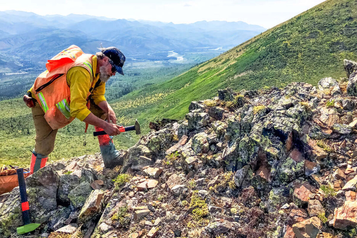
In 2023 alone, the federal geological survey invested $51M into Earth MRI scans of 35 states as part of a nationwide critical minerals search.

From rare earths in Northern Maine to lithium in Southern California and titanium in Florida to 29 critical minerals in Alaska, the United States Geological Survey is investing heavily in strengthening domestic supply chains for the 50 minerals and metals critical to every sector of the American economy.

This nationwide search for critical minerals is being carried out under the Earth Mapping Resources Initiative, or Earth MRI, a clever moniker that reflects the earth penetrating scans carried out under the program that are providing geoscientists with data needed to diagnose the best places in America to find critical minerals.

To efficiently and effectively carry out these Earth MRI scans, USGS is partnering with geologists at the state level to help identify the best places to look and to carry out the groundwork.

In fiscal year 2023 alone, the USGS distributed more than $51 million across 35 states and Puerto Rico to fund geoscience data collection and mapping in partnership with state geological surveys to identify areas of the country with potential for critical minerals.

"Investments from President Biden's Investing in America agenda are already helping us better understand our domestic critical mineral resources, a key step in securing a reliable and sustainable supply of the critical minerals that power everything from household appliances and electronics to low-carbon energy technologies like batteries and wind turbines," said U.S. Geological Survey Director Dave Applegate.  

The Maine rare earths discovery

Since the 2019 launch of Earth MRI, USGS has scanned more than 10% of America's land mass in its search of minerals and metals critical to green energy solutions, high-tech devices, military hardware, and everyday goods.

"Five years into Earth MRI we've covered an area equivalent to Montana and Texas combined with airborne geophysical data surveys," said Darcy McPhee, USGS program manager for Earth MRI. "We have also uncovered promising mineral formations in northern Maine, including rare earth elements, niobium and zirconium, which are important for electronics, defense, and manufacturing applications."

The Maine rare earths discovery demonstrates the effectiveness of the Earth MRI scans.

The discovery in Maine was made with geophysical surveys, which involve the use of special equipment attached to aircraft to image the rocks at and below the earth's surface.

Two geophysics techniques, airborne magnetic and radiometric geophysical surveys, are particularly well-suited for the initial critical minerals assessment USGS has set out to achieve with its Earth MRI scans.

The magnetic surveys allow geoscientists to "see through" nonmagnetic rocks and cover such as vegetation, soil, and water to identify magnetic anomalies that reveal geological features and potential accumulations of metals within the Earth.

The radiometric surveys identify natural low-level radiation potassium, uranium and thorium in rocks and soil, which provides clues to the type of mineralization that lies below.

In the case of the Maine discovery, the radiometric survey turned up a hot spot that is often the signature of a rare earth discovery.

A field investigation by scientists in the state confirmed that the Earth MRI scan had identified an area with a type of volcanic rock known to host rare earth, niobium, and zirconium – all on America's critical minerals list.

"This discovery shows the importance of new evaluations for potential critical mineral resources based on integrated studies involving geophysics, geology, and geochemistry," said John Slack, USGS scientist emeritus from Maine, who coauthored a scientific paper on the discovery.

Scanning America's West

While the Maine eureka moment was special due to the brand-new source and style of rare earths in an area not well known for its mineralization, most of the Earth MRI program has focused on areas further west known to be rich in minerals.

This includes scans for more than 30 critical minerals in the Ozarks of Arkansas and southern Missouri; the lithium-rich McDermitt Caldera spanning the Nevada-Oregon border; the Arizona copper belt that extends into New Mexico and is highly prospective for more than half of the minerals critical to the U.S .; and enormous swaths of Alaska, a state known to host 49 of the minerals critical to America.

In addition to scanning for new sources of critical minerals, the USGS has invested more than $2 million in cooperative agreements with 14 states to better map locations of mine waste and measure the potential for critical minerals that might exist in the tailings and waste materials from historical mining.

"These agreements are allowing us and the states to take a second look at places that were once known for their mineral production to see if there might yet be some new critical mineral potential, just waiting to be found," said Earth MRI Director McPhee.

Another priority area of research involves a partnership with NASA to collect cutting-edge, high-altitude hyperspectral information across the American Southwest.

Hyperspectral imaging collects reflections of light from surfaces, measured across hundreds of frequency bands that range from visible light into the infrared spectrum that cannot be seen with the human eye.

Because each mineral in a rock has its own unique spectral signature when reflecting the various bands of light, the data collected from a hyperspectral survey can help geologists pinpoint the best places to look for mineral resources.

Using NASA's Airborne Visible-Infrared Imaging Spectrometer high-altitude Earth remote sensing platform, USGS is collecting hyperspectral data over large regions of Arizona, California, Colorado, Nevada, New Mexico, and Utah.

"The data we're collecting will be foundational for not only critical minerals research but also for a wide range of other scientific applications, from natural hazards mitigation to ecosystem restoration," said USGS Director Applegate.

Nationwide programs, headquarters

The Earth MRI program is part of a broader $510.7 million investment being made into USGS from the Bipartisan infrastructure law.

Programs to be carried out under the funding include:

National Cooperative Geologic Mapping Program: New maps created by state geological surveys under this program are helping to refine the understanding of the geologic framework of mineral areas of interest. In addition to identifying mineral potential, these maps support decisions about the use of land, water, energy, and minerals, as well as the potential impacts of geologic hazards such as earthquakes, landslides, and volcanoes on communities.

National Geological and Geophysical Data Preservation Program: Earth MRI is partnering with state agencies to support the preservation of physical geological samples that would be costly or difficult to replace. Preserving and cataloging these samples of drill core, rock, and soil is creating rock libraries that can be referenced when geologists have new ideas or are looking for minerals that are critical to future technologies that had little or no use in the past.

USGS 3D Elevation Program (3DEP): This program utilizes private sector contractors to fill data gaps in the nation's topographic mapping in areas with potential for critical mineral resources. Lidar, a laser-based scanning of terrain to create high-resolution digital elevation models, is being used to assist in the development of more accurate maps of surface geology, which geoscientists can use to extrapolate the extent of the rock formations at depth. Lidar data can also help define the location and volume of mine waste materials exposed on the land surface.

Mineral Resources Program: Federal and state geologists are carrying out geochemical reconnaissance surveys over underexplored geologic settings, which provides initial data for planning and prioritizing future programs. This sampling of the soil and rocks exposed at surface is helping the USGS determine where to have private contractors fly airborne geophysical surveys based on the critical mineral potential seen on the surface.

USGS Energy and Minerals Research Facility: A 190,000-square-foot building being built on the Colorado School of Mines campus that will house the USGS Geology, Geophysics and Geochemistry Science Center and the Central Energy Resources Science Center. This new facility will be occupied by about 250 USGS researchers and around 170 Colorado School of Mines faculty and students working to expand upon the two institutions' long-standing partnership and history of collaborative research.

"Through the USGS and Colorado School of Mines enduring partnership and overlapping strengths, this new facility will allow us to build up America's workforce in the energy and minerals sectors, helping us solving critical mineral and supply chain challenges," U.S. Principal Deputy Assistant Secretary for Water and Science Michael Brain said during the Nov. 13 groundbreaking at the coming USGS headquarters in Colorado.

Author Bio

Shane Lasley, Metal Tech News

Author photo

With more than 16 years of covering mining, Shane is renowned for his insights and and in-depth analysis of mining, mineral exploration and technology metals.


Reader Comments(0)